WoodenBoat School Chart
Anyone who’s spent time navigating the waters around WoodenBoat knows the challenge—no single chart shows the full range of where you might go in a day. Traditionally, covering the area meant juggling multiple NOAA charts, each cutting off just where you needed it most.
This custom chart was created by Kayaking instructor and boat builder Nick Schade to solve that problem. By combining the relevant sections into one clear, continuous view, it puts the entire cruising ground—from Deer Isle to Stonington, across to Mount Desert Island—on a single sheet. Extra compass roses and distance scales make it easy to use, even when folded, and it’s printed on waterproof stock to stand up to real use on the water.
Originally developed for teaching sea kayaking navigation, it ensures everyone is quite literally on the same page. Whether you’re planning a route, identifying landmarks, or simply exploring, it’s a practical tool for anyone heading out from WoodenBoat School's Dock.
*Based on discontinued NOAA paper charts and not updated with the latest corrections. Aids to navigation and shoreline features may change—always reference current NOAA data when needed. Waterproof printing is durable but not erasable.
Here is a full description of the project in Nick's own words:
I’ve been teaching a sea kayaking class at the WoodenBoat School for years. I like to give the students some background in small boat navigation. That is most easily done if everyone in the class is looking at the same chart while out on the water. Unfortunately, the areas we can reach in an easy day paddle are covered by two NOAA charts.
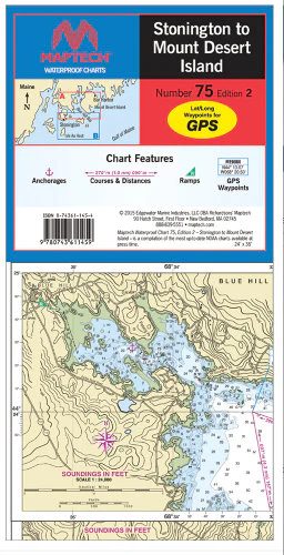
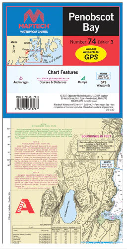
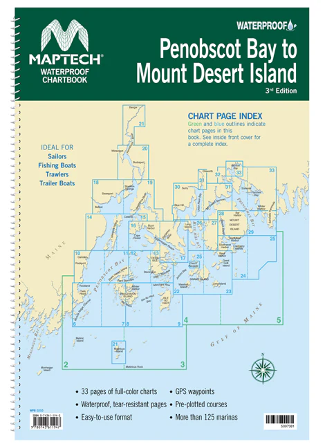
The standard NOAA Charts covering the waters around the WoodenBoat School are #13313 - Approaches to Blue Hill, which cuts off between Babson Island and the dock at WoodenBoat; and #13316 - Blue Hill Bay, which doesn’t show anything south of Stinson Neck. If we were going up Eggemoggin Reach or around Naskeag Point to Herrick Bay and beyond, we wanted #13316, and if we were going down past Stinson Neck or over to Swans, we wanted #13313. That required students to purchase two charts to cover the area.
NOAA is no longer supplying paper charts, and 3rd party charts are expensive and hard for some folks to find. I decided that it would make teaching my classes much easier if I just supplied my students one chart that showed everywhere we might go on that one sheet, so I stitched the two charts together, added some extra compass roses and distance scales for convenience when folding the chart, and since sea kayaking is a wet sport, I printed the result on waterproof paper. Now, my students can all be on the same page while we practice navigating in the waters between the bridge to Deer Isle down to Stonington, all the way over to Burnt Coat Harbor and Seal Cove on MDI. This allows us to see where we are going and also find landmarks beyond our route to assist in navigation.
Anyone doing recreational day trips boating from WoodenBoat may find this chart useful. The 1:40,000 scale shows most of the detail useful to human-powered boats and open sailboats.
This chart is based on discontinued paper charts and is not updated with the latest corrections and updates that are available in modern electronic charts. Aids to navigation may move, and other man-made features may become inaccurate, so please use the latest NOAA information when appropriate. Note that the waterproof ink used to print these charts can abrade off the waterproof plastic the charts are printed on, so pencil marks cannot be erased.
Original: $25.00
-65%$25.00
$8.75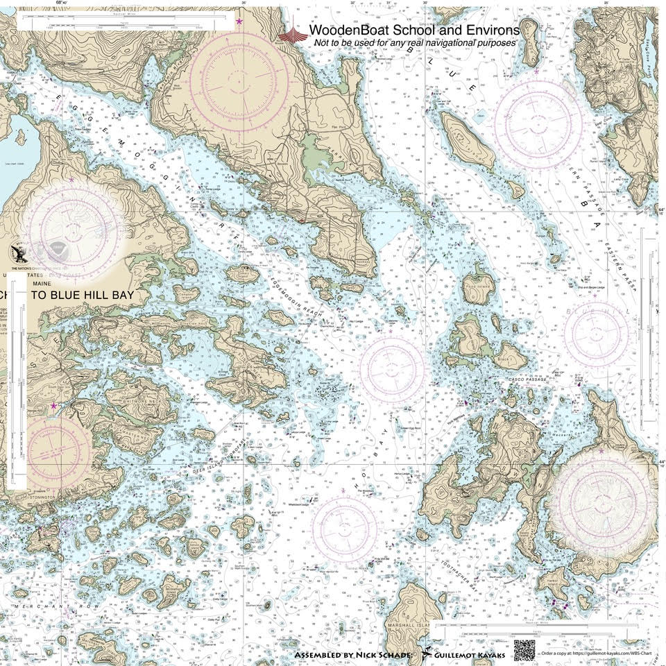
Description
Anyone who’s spent time navigating the waters around WoodenBoat knows the challenge—no single chart shows the full range of where you might go in a day. Traditionally, covering the area meant juggling multiple NOAA charts, each cutting off just where you needed it most.
This custom chart was created by Kayaking instructor and boat builder Nick Schade to solve that problem. By combining the relevant sections into one clear, continuous view, it puts the entire cruising ground—from Deer Isle to Stonington, across to Mount Desert Island—on a single sheet. Extra compass roses and distance scales make it easy to use, even when folded, and it’s printed on waterproof stock to stand up to real use on the water.
Originally developed for teaching sea kayaking navigation, it ensures everyone is quite literally on the same page. Whether you’re planning a route, identifying landmarks, or simply exploring, it’s a practical tool for anyone heading out from WoodenBoat School's Dock.
*Based on discontinued NOAA paper charts and not updated with the latest corrections. Aids to navigation and shoreline features may change—always reference current NOAA data when needed. Waterproof printing is durable but not erasable.
Here is a full description of the project in Nick's own words:
I’ve been teaching a sea kayaking class at the WoodenBoat School for years. I like to give the students some background in small boat navigation. That is most easily done if everyone in the class is looking at the same chart while out on the water. Unfortunately, the areas we can reach in an easy day paddle are covered by two NOAA charts.
The standard NOAA Charts covering the waters around the WoodenBoat School are #13313 - Approaches to Blue Hill, which cuts off between Babson Island and the dock at WoodenBoat; and #13316 - Blue Hill Bay, which doesn’t show anything south of Stinson Neck. If we were going up Eggemoggin Reach or around Naskeag Point to Herrick Bay and beyond, we wanted #13316, and if we were going down past Stinson Neck or over to Swans, we wanted #13313. That required students to purchase two charts to cover the area.
NOAA is no longer supplying paper charts, and 3rd party charts are expensive and hard for some folks to find. I decided that it would make teaching my classes much easier if I just supplied my students one chart that showed everywhere we might go on that one sheet, so I stitched the two charts together, added some extra compass roses and distance scales for convenience when folding the chart, and since sea kayaking is a wet sport, I printed the result on waterproof paper. Now, my students can all be on the same page while we practice navigating in the waters between the bridge to Deer Isle down to Stonington, all the way over to Burnt Coat Harbor and Seal Cove on MDI. This allows us to see where we are going and also find landmarks beyond our route to assist in navigation.
Anyone doing recreational day trips boating from WoodenBoat may find this chart useful. The 1:40,000 scale shows most of the detail useful to human-powered boats and open sailboats.
This chart is based on discontinued paper charts and is not updated with the latest corrections and updates that are available in modern electronic charts. Aids to navigation may move, and other man-made features may become inaccurate, so please use the latest NOAA information when appropriate. Note that the waterproof ink used to print these charts can abrade off the waterproof plastic the charts are printed on, so pencil marks cannot be erased.